
Trace an Oakton Street Record
Oakton is an unincorporated Fairfax County community, so there is no city street-records office to search. Begin with the county address layer. The aim is to establish the exact number, street name and type, unit if any, postal city, and parcel before looking at a person or a document. A returned postal label can be Fairfax or Vienna near Oakton. Retain the fields each official source returns instead of changing them to fit an expected locality.
- Search the Master Address Repository, or MAR, by address, parcel, or Street mode. Note the normalized address, PIN, subdivision, ZIP, district, and current or historical status.
- Open the matching iCare parcel card. Compare the property location with the owner display, mailing address, legal description, sales, values, and tax fields.
- Use Jade GIS to click the parcel and its street segment. Its report and layers help confirm the map location and the parcels immediately beside it.
- Use the PIN, legal description, book and page, and grantor or grantee names to locate the underlying deed through Land Records, CPAN, or the Historic Records Center.
- Check PLUS for records after October 31, 2022, then LDIH for earlier development history. Keep the address, parcel, and date range together when comparing results.
A street-by-street result is strongest when it identifies the record type and date. Ownership, mailing contact, parcel geography, and a current household are different questions, and the county sources answer them differently.
Oakton Address Fields for Street Searches
MAR is Fairfax County’s address-normalization layer. Address mode accepts an address number, street name and type, city, ZIP, parcel ID, and subdivision. Created and expired date ranges, plus Current, Historical, or All status, make it useful where an address form may have changed. Street mode can return address rows and export a CSV. That makes MAR the better starting point for an inventory of official address records, while iCare supplies the assessment card tied to a matched parcel.
The Fairfax iCare address search shows the fields used for the next step.
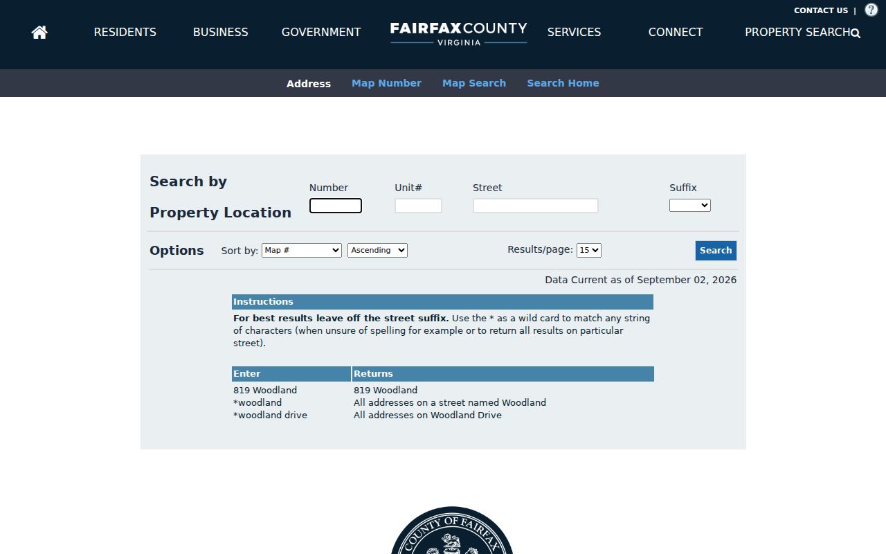
Its form supports a street number, Unit#, Street, optional Suffix, sorting, and result-count controls. Asterisks may be used before or after a street name, which is useful when a road type is uncertain.
| Tool and control | Use on an Oakton street | What to retain |
|---|---|---|
| MAR Address mode | Filter number, street name/type, city, ZIP, parcel ID, or subdivision. | PIN, status, effective dates, ZIP, district, and normalized address. |
| MAR Street mode | Search a named road and select current, historical, or all records. | Returned address rows and the CSV retrieval date. |
| iCare Number and Unit# | Enter the known number and unit identifier. | The matched property card, not an assumed match. |
| iCare Street and Suffix | Use a wildcard around a partial name; leave Suffix blank if it is not needed. | Street spelling, suffix, and result ordering. |
| Jade selection tools | Use Point, Box, Poly, Line, or Freehand after locating the segment. | Selected parcel and the report date. |
Oakton Parcel Cards by Address
iCare is the Fairfax Department of Tax Administration assessment site. A card can display an owner, a mailing address, the situs or property location, PIN, legal description, physical characteristics, sales, values, taxes, zoning, and land-use information. The owner display can be withheld online on request. Even when a name appears, it is an assessment field and not a full household roll.
The Oakton iCare parcel example illustrates the kind of assessment information that follows a confirmed PIN.
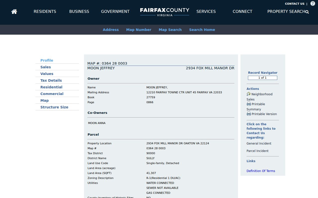
Use the card to distinguish the situs from the mailing address. Tax correspondence may go to an office, a different residence, or an address outside Oakton. It does not establish current occupancy at the parcel. For a display or assessment question, the DTA fallback is 703-222-8234.
Map Oakton Streets in Jade
Jade GIS turns the address and PIN into a map task. Search for an address, place, or parcel, turn layers on or off, then click to identify a parcel or open a report. Point, Box, Poly, Line, and Freehand tools can select a street segment or group of parcels. The report provides a map-based snapshot that can be compared with MAR and iCare.
The Fairfax Jade parcel report is the source for this example of the reporting view.
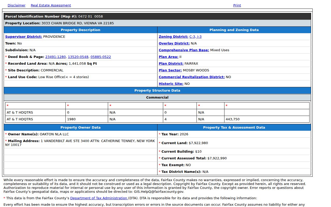
Jade can show parcel geometry, zoning, districts, and nearby parcels. It is not the legal source for title or easements. Confirm those questions from the recorded instrument, plat, and Land Records route.
Oakton Records Tied to a Street
Each address-keyed source has a narrow role. MAR records address status and geography. iCare records assessment data. Jade provides a map view. Deeds carry the recorded transfer and legal description. Development systems describe applications and permits. A historical directory can offer a dated address-to-occupant clue, but the inspected research did not verify a complete Oakton shelf run. Match the source to the question before drawing a conclusion.
| Address-keyed record | Custodian | What it can show | Access route |
|---|---|---|---|
| MAR | Fairfax addressing | Address, PIN, ZIP, subdivision, district, and current or historical status. | Free viewer and CSV export. |
| iCare assessment | Fairfax DTA | Owner display, mailing and situs addresses, legal description, values, sales, and taxes. | Free address, map, and map-number searches. |
| Jade GIS | Fairfax GIS | Parcel geometry, layers, zoning, districts, and map reports. | Free map and identify tools. |
| Land records | Fairfax Circuit Court | Deeds, plats, liens, releases, and book or document references. | Research Room terminals, CPAN subscriber access, and copy requests. |
| PLUS and LDIH | Land Development Services | Building, site, zoning, complaint, and environmental-health records. | Public portal searches by address or parcel. |
| Criss-cross and directory clues | Virginia Room and digitized Virginia collections | Dated address-to-occupant, telephone, spouse, or occupation notation where printed. | Collection access; the exact Oakton run remains partly unresolved. |
| Voter records | Virginia Elections and Fairfax Elections | Address-specific precinct, district, polling, and status functions. | Voter-facing or authorized process, not a public street roster. |
When one record points to another, preserve the identifier that made the connection: PIN, instrument number, book and page, application number, or the exact historical address status. That is more useful than a loose street-name match.
Oakton Deed and Plat Trails
After iCare supplies a PIN and legal description, Land Records can turn an address search into a deed chain. Start with the current transfer, then search the seller as a prior grantee. Read the legal description and any “AND BEING” reference, which points back to an earlier instrument. For a subdivision, compare the lot, block, section, acreage, plat, and adjoining tracts because a street number may change while the legal tract continues.
Land-record images extend from 1742 to the present. The Historic Records Center has original deed books from 1742 through 1942, and courthouse research terminals supplement CPAN’s subscriber internet access. Index and image coverage are not identical, so an older search can require a book, microfilm, or the Research Room. The phrase grantor means the party transferring an interest; grantee is the party receiving it.
- Parcel
- A county tax unit identified by a PIN. It is not the same thing as a postal street address.
- Situs address
- The property location used for the parcel, distinct from the mailing address for tax correspondence.
- Plat
- A recorded map that can identify subdivision lots, blocks, boundaries, and related tract details.
- Criss-cross directory
- A reverse-format directory that begins with an address and may offer a dated occupant or telephone clue.
Oakton Permit History by Street
PLUS and LDIH add a development-history layer to an address or parcel. PLUS is the public path for records after October 31, 2022. LDIH preserves the earlier legacy layer and can reach construction-oriented history toward the early 1980s. Search by address or parcel and record the submitted terms, record type, project, and dates. A result may identify an application or contractor role, not everyone associated with the property.
For an approved new address, Fairfax says MAR, PLUS, and iCare receive the change on the next business day. Other agency systems can take up to a week. Address changes are submitted in PLUS. This timing explains why a recent update can appear in one county system before it appears in another.
Oakton Street Names and Historical Status
Do not invent a local renumbering date. The inspected sources did not verify an Oakton-specific renumbering or street-renaming year. MAR’s Current, Historical, and All selectors, with created and expired dates, are the evidence path when an older record uses a different form. PLUS address-change records and the legal description can help bridge the same property across the change.
Fairfax Maps announced an improved MAR interface on July 31, 2026, aimed at phone and tablet use. The screen can change while the important fields remain the same. Save the source URL, retrieval date, returned status, and PIN whenever a street result is used as a record lead.
Oakton Street and Postal Context
Oakton community geography, the postal city, a ZIP, voting geography, and a tax parcel are separate attributes. A person may supply “Oakton” while a returned address is Fairfax 22033 or a nearby Vienna postal line. MAR, USPS, iCare, and Jade should be allowed to return their own locality fields. The discrepancy is a verification note, not proof that one agency’s record is wrong.
Once a ZIP narrows an address search, the Oakton ZIP Codes record explains the two verified postal areas and the limits of their boundaries. For the named street and parcel sequence, return to MAR and the county parcel sources rather than treating a ZIP as a street-level record.
Oakton Street Election Context
The Virginia Citizen Portal is voter-facing. It offers functions for registration and status, address updates, polling place, election district, absentee activity, and voting history. Fairfax’s My Neighborhood tool can also give address-specific precinct and public-place context. Neither source establishes a public list of everyone along a street, and ballot choices must never be inferred.
Virginia Code §24.2-405 limits distribution of the full voter file to specified categories and prescribed purposes. The related Statement of Responsibility requires a requester category, purpose, authorized use, and felony certification. Where a voter is protected, or a source shows an Address Confidentiality Program substitute address, stop rather than trying to reconstruct a location from linked records.
Oakton Streets in Historical Sources
For a dated address clue, the Virginia Room combines regional directories, telephone books, maps, newspapers, manuscripts, microform, and a CPAN station. The research identifies Hill’s Arlington County Criss Cross run from 1955 through 1976 as an adjacent Northern Virginia lead, but it does not prove coverage for every Oakton year. The statewide Virginia city-directory collection is described as 1873 through 1960, yet a verified Oakton page and full local shelf run remain gaps.
Use a historical directory as a date-stamped lead, then match it to a legal description, tax record, or deed. The Oakton Directory Book collects the historical-shelf access routes without turning a partial directory run into a current address list.
Oakton Public Places Near a Street
My Neighborhood can return nearby schools, libraries, police and fire facilities, post offices, hospitals, parks, elected officials, precincts, polling places, and public-safety context for an address. It is useful for placing a street in its civic setting. Oakton Community Center at 3000 Chain Bridge Road and the Waples Mill site at 11509 Waples Mill Road are public-place anchors, not household evidence.
This countywide context is especially useful where Oakton touches Providence, Hunter Mill, or Sully district areas. Confirm the exact district from an address-based county source rather than assuming it from a community name.
Limits of an Oakton Street Directory
No inspected public source provides a complete current household list for an Oakton street. The county records do not create a public roll of every person at an address. Utility, delivery, private association-member, and motor-vehicle address data are not a public street roll. A permit can name an applicant or contractor and an assessment card can show an owner display, but neither identifies every person connected to the parcel.
Use the minimum fields needed to identify a record, then return to the custodian for a correction or a controlled-access question. A protected voter flag, sealed record, juvenile record, law-enforcement address, or ACP substitute address is a stop signal.
Lawful use. Address and parcel records support personal, lawful research and property history. Virginia Code §18.2-60.3 addresses stalking, and §18.2-152.7:1 addresses computer harassment; do not use records to monitor, threaten, or repeatedly contact another person.